


Vic Spatial
Unlock the power of precision with our expert drone surveying services. Specialising in asset management, photogrammetry, and LiDAR, we deliver fast, accurate, and cost-effective data solutions for projects of all sizes. Whether you're tracking infrastructure, mapping terrain, or managing land assets, our advanced drone technology ensures reliable results with minimal disruption.
Services

Terrestrial LiDAR/Photogrammetry
Our Terrestrial LiDAR services offer precise and detailed land surveying data for various projects. Trust Vic Spatial for accurate measurements and topographic mapping.

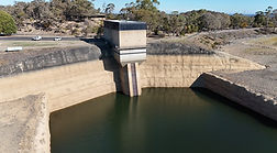
Aerial LiDAR/Photogrammetry
Experience the efficiency of our Aerial LiDAR services that provide high-resolution aerial surveying data. Vic Spatial ensures quality data collection for your projects.
Aerial Photography/Asset Inspection
At Vic Spatial, we combine traditional surveying methods with modern technology to deliver comprehensive survey solutions. Trust our expertise for reliable and accurate results.
Our Surveying Story
About Us
Vic Spatial, a leading Melbourne-based surveying firm, specializes in feature & level, earthmoving and monitoring surveys. We cater to clients in large-scale developments, utility providers, and government departments. Utilizing state-of-the-art equipment, we provide insight for the design and decision making process. With professional training and certification recognized nationally, we are able to operate terrestrial and aerial LIDAR, Photogrammetry, GNSS and Total Station equipment. With almost a decade of experience, you're in safe hands with Vic Spatial.

Projects & Case Studies

_edited.jpg)

_edited.jpg)
_edited.jpg)
_edited.jpg)